
The Bay of Fundy is located in New Brunswick on Canada’s Atlantic Coast and is one of the Marine Wonders of the World with tides rushing in and rising up to 16.3 metres (53 feet) over a 12 hour period twice each day and later rushing out. The enormous height of the tides make them truly magnificent! The change from high tide to low tide is astonishing due to both the difference in height of the water and the dramatic shift of the shoreline forward. During low tide you can walk the ocean floor and explore the area more in-depth. Make sure to check the tidal tables online to check when high and low tide will be occurring. Visiting the Bay of Fundy is a remarkable and unique experience. What’s more, the coastline is breathtaking and there are a variety of adventure activities available.
The must-see tidal phenomena along the Bay of Fundy coast, in no particular order, are:
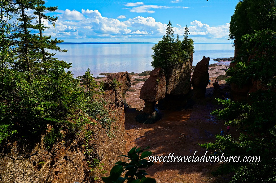
The Hopewell Rocks
Lover’s Arch From Above at the Hopewell Rocks During Low Tide in New Brunswick
About 35 minutes from Moncton, or 47 km (29.2 miles), is the Hopewell Rocks. These are massive rock formations that have been formed over millions of years and been eroded by glaciers, tides, wind, snow, and ice to create their different shapes. The rocks can be found at Hopewell Cape and the park (which was officially taken over by the province in the late 1950’s) is open from mid-May to mid-October.
There is 1.5 km (0.9 miles) of shoreline where you can walk during low tide, and the park is 51.8 hectares (128 acres) in total, but this is mostly woods and trees. Moreover, low tide gives you the chance to check out the large rocks on the beach and the cliff face behind the beach. About 13 000 years ago (at the end of the last ice age) as ice melted the waters rose and Hopewell Rocks started having high tides twice a day which caused erosion in the rocks and 100 metres (328.1 feet) of cliff. The cliff face is slowly moving back and getting smaller (about 1 metre or 3.3 feet a year) due to erosion.
The cliff therefore varies in size; with the highest cliff being 35 metres (114.8 feet) high. The low-lying rocks on the beach used to be part of the cliff face. As the tide recedes, if there are no waves and the water is calm, then sediment is laid down and left on the beach. Conversely, if there are a lot of waves and wind all the sediment gets washed away.
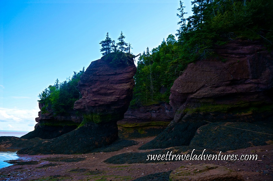
The Hopewell Rocks are often called flower-pot rocks. A flower pot rock is a rock that has been separated from the cliff and gets surrounded by water at high tide. This name was originally given in 1936 by Robert Ripley of Ripley’s Believe it or Not who visited the park and saw a rock with trees growing out of the top of it and thought it looked like a flower pot. He later published his magazine with a picture of it and called it “the amazing flower-pot rock of Hopewell Cape New Brunswick.” Since then, the name was adopted.
Flower-Pot Rocks at the Hopewell Rocks in New Brunswick
The rock at Hopewell Rocks is sedimentary conglomerate rock which washed in from elsewhere, mostly the Caledonian mountain range which eroded. Over time, the sediment turned into a solid piece of rock as it built up layers over a period of a few million years. The sheer size of the rocks alone is quite impressive.
One of the most popular rocks is Lover’s Arch, as the archway itself looks like two rocks leaning in and kissing one another. An alternative theory is that they are two rocks leaning against each other and supporting each other through the highs and lows of tidal life. Many people get married under Lover’s Arch during low tide and many marriage proposals also occur there.
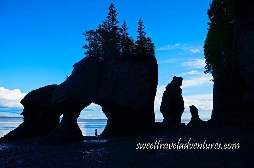
Lover’s Arch at the Hopewell Rocks in New Brunswick
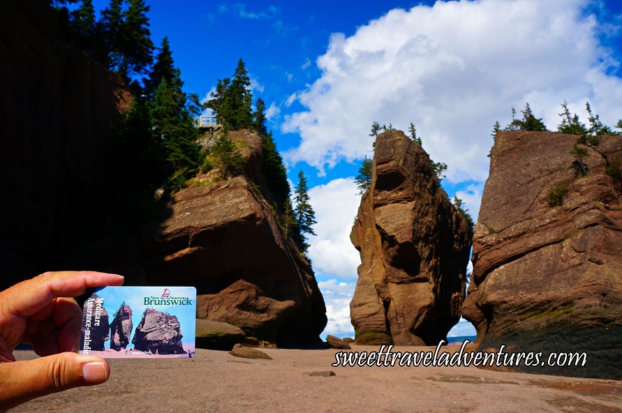
Another very famous rock is Elephant Rock as the rock looks like an elephant. A picture of Elephant Rock appears on New Brunswick’s health care cards. Unfortunately, some years ago, a piece of the rock that looked like the elephant trunk broke off due to erosion. However, there is another rock called Baby Elephant Rock as it also looks like an elephant, but in a smaller version.
Elephant Rock at the Hopewell Rocks in New Brunswick
A rock that is often noticed from the viewing deck above is Mattress Rock. People often report it as it looks like an old mattress washed up on the beach. In actuality, it is a rock from Greenland (which is why it looks so different from the other rocks) and floated into the bay in the late 1920s or early 1930s. Furthermore, there is a rock shaped like a diamond, which is why the last cove is called Diamond Rock Cove. In addition, there are several other rocks with unique shapes and names whose locations are indicated on the park map.
Migratory shore birds can be found at Hopewell Rocks from mid-July to about mid-September. The birds are from the Canadian Arctic where they nest and stop here to feed and rest before continuing their journey to South America. The two areas where the shorebirds feed at either end of the park are protected. The majority of the birds are semi-palmated sandpipers which feed on mud shrimp in the mud flats until they double their body weight. Mud shrimp are a type of crustacean.
The time passed quickly during my tour of the area as my guide was very informative, knowledgeable, and friendly, which made my experience even better and the Hopewell Rocks even more interesting. The park provides free walking tours which last about 1 hour. You can inquire about them in advance or upon arrival at the park entrance. The times vary each day depending on the tides. Bus tours are also available which last about 1.5 hours.
I visited the park at low tide which gave me the opportunity to truly appreciate the rock formations as well as walk the ocean floor and explore the beach and coves. I even saw one of a pair of Peregrine falcons that nest within the park. It was sitting in a tree that was growing out of the cliff behind the beach. Although the pair of falcons had 3 babies that grew up and flew away, the parents come back every year. However, where they lay their nest changes slightly every year.
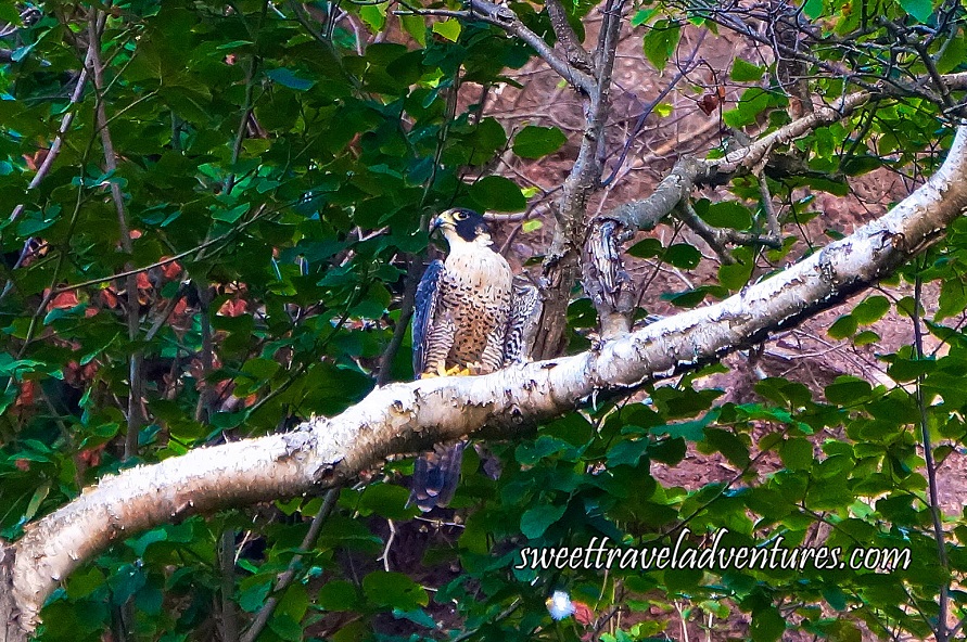
A Peregrin Falcon in a Tree at the Hopewell Rocks in New Brunswick
In addition, I explored the park on my own after the tour so I could truly take in what I had learned, appreciate the scenery, and take photos. Since I stayed for several hours I got to see the shift to high tide where water began to fill the bay and the formations became surrounded by water. It was astounding to see the difference between low tide and how much water there was at high tide (both the height and range of the tides) and how quickly the beach disappears. An example of how high the water can get is that Lover’s Arch will fill to the top of the archway with water.
It is important to note that the tides depend on the lunar cycle; different times of the lunar cycle there are different size tides. The highest tides occur during new moon and full moon whereas the lowest tides happen during quarter and three quarter moons. At Hopewell Rocks the tide rises about 4 meters (6-8 feet) an hour. When water goes from low tide to high tide the water comes back slowly, but speeds up in the middle of the cycle. It then slows down again as it gets closer to high tide. It takes 6 hours and 13 minutes to go from low tide to high tide and 12.5 hours to go from low tide to high tide and back to low; hence there are two tides a day. The tides move forward 52 minutes a day so the following day the tide will be 52 minutes later, thus over a week the high tide on a particular day and time will then become the time for low tide.
The tides can be viewed from above on the upper viewing deck. If you wish to walk down the 98 steps to walk on the ocean floor, this may only be done from 3 hours before low tide until 3 hours after low tide, as after that areas of the beach start becoming submerged very quickly. Therefore, make sure to check the tide tables schedule before you visit. Additionally there is a network of walking trails which are connected to various other lookout decks, each showcasing a different view of the rock formations and the Bay of Fundy coastline.
The park has two sandy beaches, called Seawall Beach and Demoiselle Beach, which are adjacent to marshland. Furthermore, Hopewell Rocks has an interpretive centre with a multi-media exhibit, interpretive program, gift shop, and restaurant. Kayak tours are available at high tide for the extreme.
Cape Enrage
Cape Enrage Lighthouse and Cape House Restaurant in New Brunswick
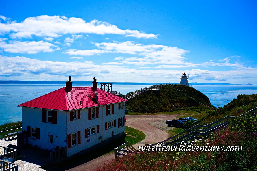
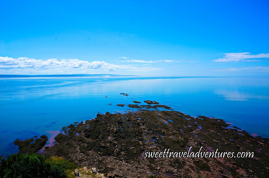
The lighthouse at Cape Enrage is located about 1 hour 15 minutes from Moncton or 80km (50 miles) and about 25 minutes from the Village of Alma or 14-17 km (9-11 miles) depending on the route taken. It is situated on a high cliff, giving it one of the most spectacular views of the Bay of Fundy. Cape Enrage has been called one of the “Best Views in Canada” by Frommer’s travel guide in 2004. Moreover, it was one of the locations for the Amazing Race Canada in 2014.
Cape Enrage juts out into the bay almost halfway to Nova Scotia and was given its name for its extremely turbulent waters which caused many shipwrecks. It is one of the most hazardous areas for mariners in the upper Bay of Fundy. The main reason the water gets violent is the large reef that points south and extends out into the bay. Turbulent waters can occur for about a kilometer southward at low tide. However, during windy days they carry on much farther due to the current and wind often pushing in opposing directions. It is especially dangerous during mid-tide when the reef is partially exposed and the water is in motion.
View From Cape Enrage Lighthouse in New Brunswick
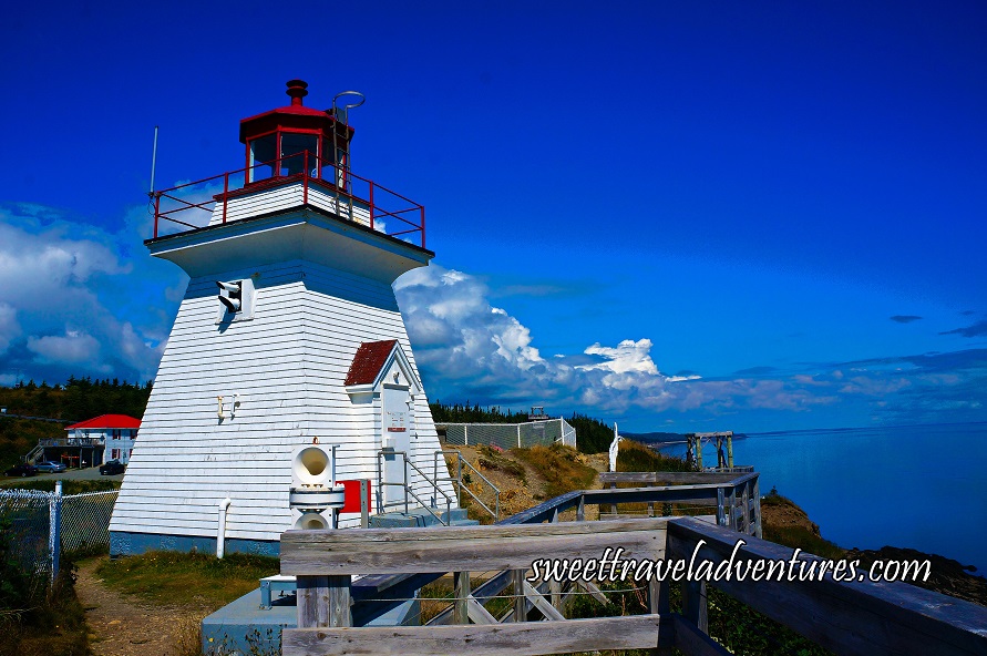
Local residents and sea captains petitioned to have a lighthouse built at Cape Enrage in 1838 as the busiest trade route was past Cape Enrage at the time and they wanted to make it safer for sailors who had a tendency to travel too close to Cape Enrage in the winter, as they were trying to avoid the ice along the south shore of Nova Scotia.
The Cape Enrage light station and fog alarm was originally constructed in 1840, making it one of the oldest on the Fundy coastline. In 1870 a second lighthouse, which is the current one, was built. Since the 1980s, the lighthouse itself has been automated and unmanned.
Front of Cape Enrage Lighthouse in New Brunswick
Cape Enrage has now become part of an island as its sole connection to the mainland is currently a beach-head, which is where a road has been built in order to reach it on the southern tip of the island. Barn Marsh Creek separates the mainland from what is presently called Barn Marsh Island.
There are many adventure activities offered at Cape Enrage, including; zip-lining, rappelling, rock climbing, kayaking, an obstacle course, custom adventures for groups, and more.

Cape Enrage Zipline and Cape House Restaurant and Patio in New Brunswick
A gourmet chef that has worked and trained internationally and nationally runs the historic Cape House (restaurant) there, which serves lunch and dinner in its dining room and patio, as well as a selection of beers and wines. A take-out menu is also available.
In addition, there is a gallery that features works from local artists and artisans for sale; including paintings, carvings, photography, jewellery, maple products, jams, and more.
Alma
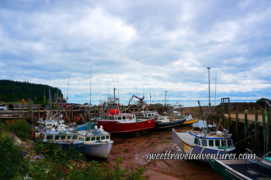
Fishing Boats Sitting on the Ocean Floor at Low Tide in Alma, New Brunswick
This village is situated about 1 hour 7 minutes from Moncton or 79.1 km (49.2 miles) and is next to Fundy National Park. The economy is fueled by lobster and scallop fishing; thus Alma is known for its seafood chowder restaurants. Plus, it has a picturesque wharf where you can easily view the ocean during high tide or low tide and the effects on the shoreline. It is quite interesting to watch the fishing boats ride the tides when it is high and return back with fresh seafood or witness the fishing boats sitting on the ocean floor, which is exposed, at low tide.
St. Martins
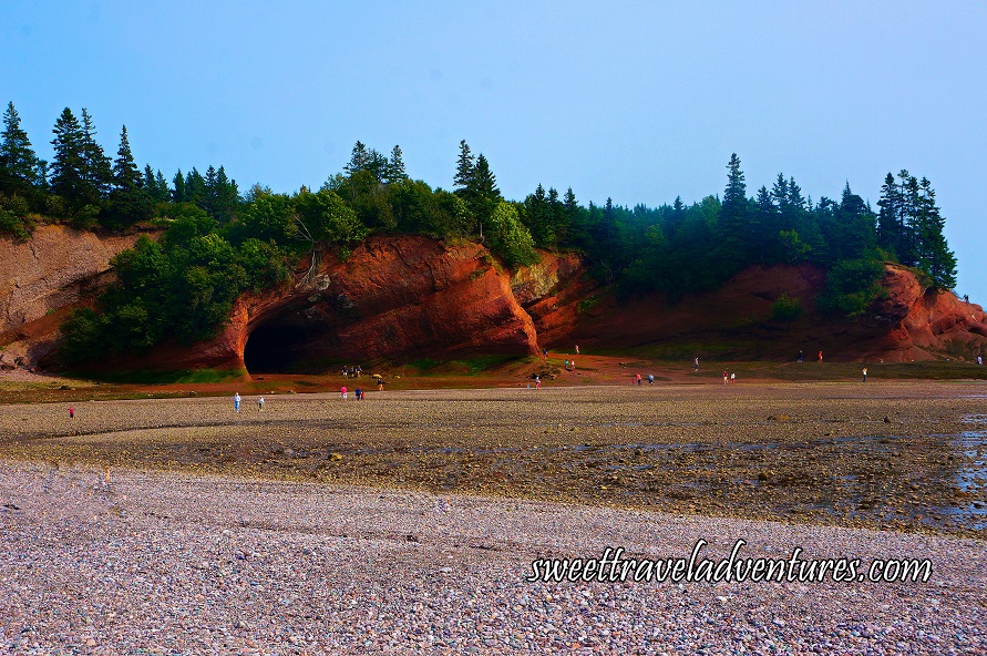
Close-Up of St. Martins Sea Caves at Low Tide in New Brunswick
This village is located about 45 minutes from Saint John or 53.9 km (33.5 miles) and about 30 minutes from Fundy Trail Parkway or 19.7 km (12.2 miles). St. Martins was originally settled in 1783 with a former focus on shipbuilding and shipping. The main attraction today is its sea caves, which can only be explored during low tide. The sea caves are relatively large and deep and were formed by erosion. They are composed of sandstone and sedimentary rock; some of the latter dates back to the Triassic age, about 250 million years ago, when the Atlantic Ocean just started opening up and dinosaurs first began to appear on Earth.
It is quite interesting to see the difference between low and high tide since it is so dramatic. I recommend visiting other places of interest in St. Martins as well as the Fundy Trail Parkway and then returning to see how the shoreline has changed. There is a beautiful beach right near the sea caves in addition to a few seafood restaurants. Nearby there is a harbour with fishing boats, two lighthouses, and two covered bridges.
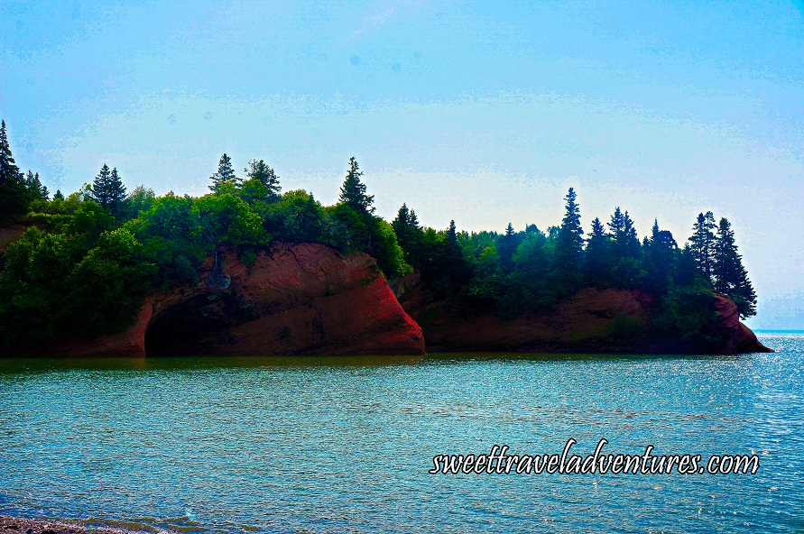
Close-Up of St. Martins Sea Caves at High Tide in New Brunswick
Conclusion
The Hopewell Rocks, Cape Enrage, and St. Martins Sea Caves are all part of the Amazing Places, 50 exceptional destinations of the Fundy Biosphere Reserve, which is designated by UNESCO as one of the world’s most unique landscapes. Each are marked with a smartphone-enabled sign, therefore enabling access to interpretive information about the site.
St. Martins is also part of the Stonehammer Geopark, one of the first places to be explored by geologists in Canada and an area recognized by the UNESCO supported Global Geopark Network for having exceptional geological heritage which is linked to archaeology, wildlife and habitats, history, and/or folklore and culture.
A visit to the Bay of Fundy is sure to provide you with natural history, breathtaking scenery, and a unique tidal experience that you won’t soon forget!
Check Out My Experience of the Bay of Fundy!
Map of the Bay of Fundy
loading map - please wait...
Have you ever visited one of the wonders of the world? If so, where did you visit? If not, is there a place that you would like to visit?
This was a complimentary trip courtesy of New Brunswick Tourism. As always, all opinions are 100% my own.

